FAQ: Angkor Resources' Seismic Program and South Bokor Lead Discovery in Cambodia
Summary
Angkor Resources' subsidiary EnerCam has identified a significant anticline structure called the South Bokor Lead from preliminary seismic data on Block VIII in Cambodia, marking the first drill target in the company's mission to discover Cambodia's first commercial onshore oil and gas.
What is the main announcement from Angkor Resources?
Angkor Resources’ subsidiary EnerCam has reviewed preliminary seismic data from the South Bokor Basin on Block VIII in Cambodia and identified a substantial anticline structure called the South Bokor Lead, which has been confirmed as the first drill target from the seismic program.
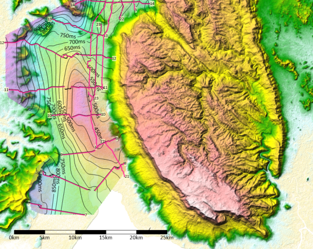
What is the South Bokor Lead and why is it significant?
The South Bokor Lead is an anticline structure with approximately 48 square kilometers of closure located between 900-1500 meters from surface. It’s significant because anticlines contribute to the majority of global oil and gas discoveries, and this represents the first drill target identified from the seismic program.
When will more complete data and interpretation be available?
Seismic processing and integrated geological and geophysical interpretation is expected to be completed in November, with remaining data from other areas expected in segments by the latter part of October.
Why is this project important for Cambodia?
The mission is to discover Cambodia’s first commercial onshore oil and gas, as the country currently imports all its hydrocarbon-based energy products, spending several billion dollars per year on imports.
Who is involved in this seismic program and where is it located?
The program is conducted by EnerCam Resources Co. Ltd. (Cambodia), Angkor’s subsidiary, on Block VIII in Cambodia. It employed 38 Khmer residents with 15 contractors from Thailand using EnviroSeis equipment across three provinces.
What is an anticline and why is it important for oil and gas exploration?
An anticline is an arch-shaped structure formed by compression where fluids may collect and be forced to the uppermost portion of the dome. Anticlines contribute to the majority of oil and gas discoveries globally, but require an impermeable rock layer on top to trap hydrocarbons.
What geological time periods are represented in the mapped structure?
Layers above the mapped horizon are thought to be Cretaceous-Jurassic age while layers below are thought to be Lower Jurassic to Permian in age, based on analogs from the Khorat Plateau in Thailand.
What are the next steps in the exploration process?
The company will continue interpreting the remaining seismic data expected in October, with full interpretation completion in November, and has confirmed the South Bokor Lead as the first drill target for potential drilling operations.
How extensive was the seismic program conducted?
The seismic program included 24 lines across three provinces in Cambodia, with the South Bokor Basin being the first of four subbasins covered and the first area where seismic was shot in early August.

This story is based on an article that was registered on the blockchain. The original source content used for this article is located at NewMediaWire
Article Control ID: 244068